Gunung Merbabu, Central Java, Indonesia
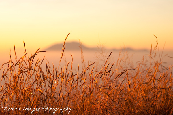
Mount Merbabu (3,145m) as seen from Bandungan
Climbing or Hiking Gunung Merbabu (mount merbabu in english) whichever is your preferance is one of those unforgettable treks that you will be in your memories for a lifetime if you are in central Java and you get a chance to do it. It's not an easy trek mind and takes roughly 7 hours to reach the summit, including a few lengthy breaks along the way and 5 hours to descend, so with an hour or two up there to take in the mind blowing views it is quite an harduous trip!
Merbabu with Gunung Merapi in the background
Mount Merbabu is a dormant stratovolcano so you have no fear of nasty eruptions taking you by surprise unlike its neighbour across the way, the highly active Mount Merapi. The spectacular views from the summit of Mount Merbabu are said to be some of the best in Indonesia and I'm not going to contest that. Many other Volcanoes can be seen from the peak and of course the best time to take in this otherworldly scene is at sunrise...
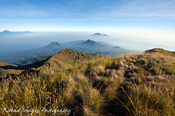
Views to the north (Watu Tulis - old radio mast at 2,900m)
From the summit you have a 360 degree vantage point of unbelievable natural beauty laid out before you like an enchanting Persian rug. In a word, Magical..
- To the west you see Gunung Sumbing, Gunung Sindoro and the Dieng Plateau
- To the north you see Gunung Telemoyo and Gunung Ungaran
- To the south you see Gunung Merapi
- To the east you see Gunung Lawu
Twin Peaks - Gunung Sumbing and Gunung Sindoro
The Ascent - Starting Point
There are two ways to ascend Mount Merbabu, either by way of Selo to the south of the mountain which is located in-between Merbabu and Merapi (steeper ascent) or via Kopeng (northwestern flank) and easily accesible from Salatiga City.
Kopeng itself isn't the true start point but as it is a local tourist destination there are lots of cheap hotels and eateries and places to pick up some food and drink for the trek. There are a couple of true start points which are also a couple of km's walk away from Kopeng unless you can find an Ojek (motorbike taxi) to take you to the small basecamp and hut where you pay a small fee and register at Tekelan village or at Cuntel village which is where I opted to start the climb from.
Watu Tulis (second summit) and the old radio antenna at 2900m seen from Kopeng
The Hike
Merbabu consists of seven summits in total although not all are what we would actually call true summits but they are good reference points nevertheless. A lot of people do this hike with an overnight camp at one of the summits where there is ample room to put up a small tent. Personally I walked through the night again as it is cooler and aimed to arrive at the summit for the spectacular sunrise for around 5.30am which I succeeded in doing. It was the night of a full moon when I set off at 10.30pm from Cuntel basecamp.
From here you walk a while on a well marked path beside cultivated fields until the route starts ascending at a steeper angle through the pine forested slopes. Its a very meditative to be walking in silence with the pine forest smell, that aromatic citrus scent flooding into your nostrils and beckoning you onwards but alas it ends all to soon when finally after passing a number of small camp grounds or Pos -
- Pending - 1,936m
- Pereng Putih - 2,162m
- Gemuk Menthul - 2,330m
- Lempong Sompan - 2,510m
You begin to notice less trees now but the views begin to open up and on a full moon with a star filled night sky what better way could there be to experience climbing Gunung Merbabu! The views to the east of Gunung Sumbing and Sindoro looked surreal with a faint wisps of cloud gentle passing by...
Gunung Sumbing on the night of a full moon
Salatiga City seen from summit 2 Watu Tulis
The Seven Summits
- Watu Gubug - 2,735m
- Watu Tulis - 2,900m
- Geger Sapi - 2,987
- Syarif - 3,119m
- Ondorante - 3,000m
- Kenteng Songo - 3,142m
- Tringulasi - 3,145m
Watu Gubug is little more than a mound although to fit in with the name of the hike 'Seven Summits' I guess something has to be included.. Watu Tulis or summit 2 is a great landmark, the old radio mast or antenna with an old 'bunker' which can be used as a shelter is good place to shelter from cool winds as you are quite exposed to the elements at this stage. I actually carried wood up (as there is little up here) from pos 4 and made a fire here and had a good long rest before the final push. Expect between 3 and 4 hours walking to reach this point.
Gunung Lawu from Syarif
From Watu Tulis the path becomes narrow as you are walking on a ridge and drops down before climbing back up to summit 3. Just before you start ascending again there is a steep little path down to your right where you can find a source of water. I needed a refill so ventured down here although much to my astonishment after research led me to believe it was quite close I found myself with quite a trek on to get down to the spring which is located nearby yellow sulphurous clay and air panas (hot springs) and back upto to the main track! The Tekelan route also joins the Cuntel route around this point.
Gunung Merapi at Sunrise
Summit 3 again is not much of a summit but from here on in the ascent becomes very steep and relentless until you finally arrive at summit 4 which is Syarif. Views from here are astounding, absolutely breathtaking and there is space for a number of tents here on a flat sandy area surrounded by long grasses and slopes which drop away on all sides. Here you can actually see the true summit and the path upto Kenteng Songo. You don't need to bother with Odorante as you can skirt around the side of this.
True summit of Gunung Merbabu with sunrise casting a shadow of the peak
Gunung Lawu to the east at first light
After dropping down from summit 4 Syarif you circumnavigate summit 5 Odorante and then it is a final steep climb again to Summit 6 Kenteng Songo and but a stones throw away from this you will find yourself on the true summit Triangulasi at 3,145m with more astounding views especially of Mount Merapi just over the way. From here you can choose to return the way you came or descend to Selo village a steep knee trembler of a trek back down and if you haven't already done so stay there the night and go for a Mount Merapi ascent the following night!
Selo village nestled in-between Mount Merbabu and Mount Merapi
Wide angle view
View Larger Map
Interactive Google Maps Location Gunung Merbabu
Labels: climb, gunung, gunung merbabu, hike, Hiking, indonesia, java, jawa tengah, Landscape, merapi, merbabu, mount, mount merbabu, Mountains, peaks, summit, Trek, volcano, volcanoes